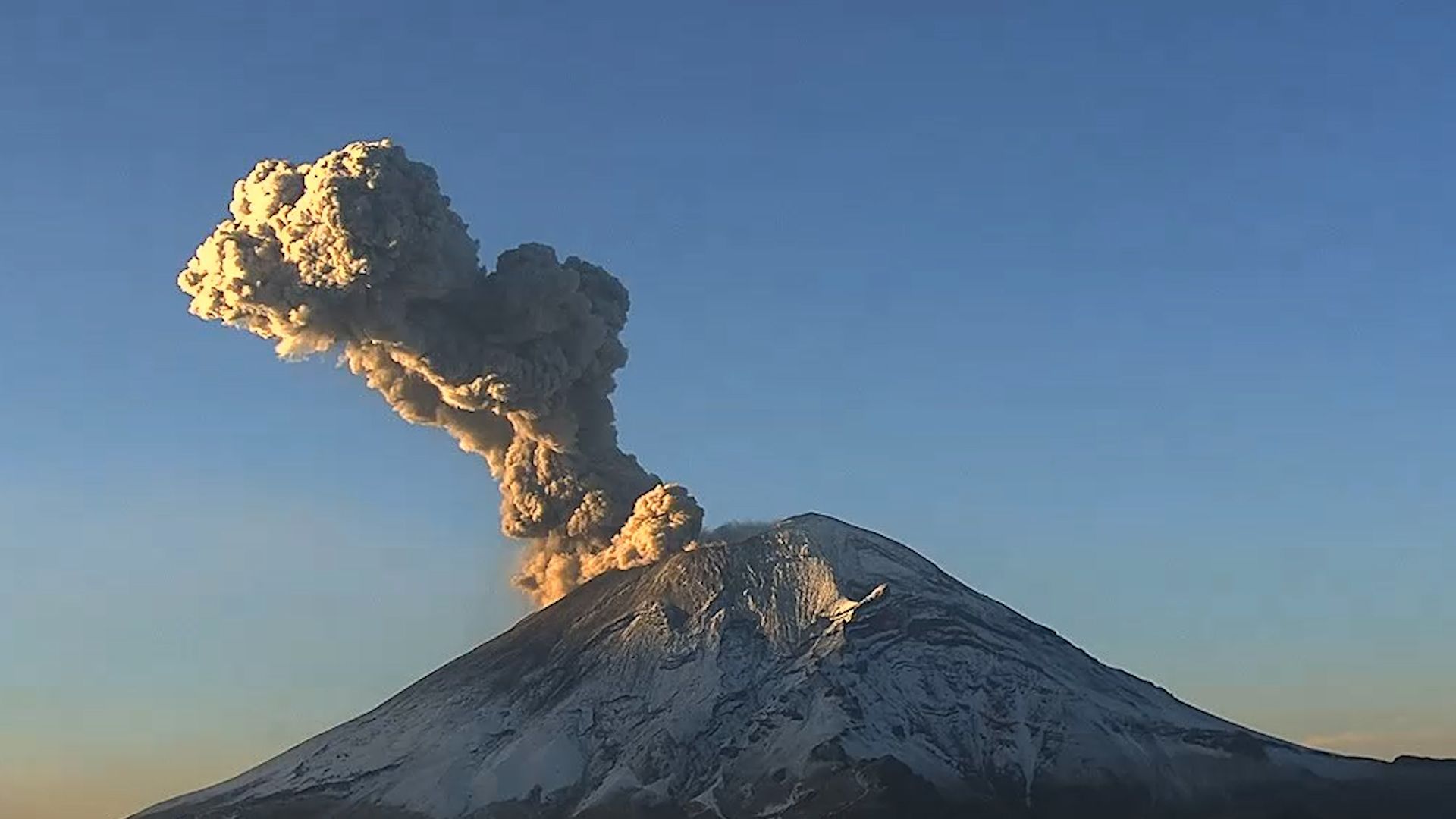
Popocatépetl smokes again
The 7 most dangerous volcanoes in the world: Popocatépetl ranks among the top places
According to Nat Geo, out of the 1,350 active volcanoes in the world, these are the most dangerous ones.
Of the 1,350 active volcanoes in the world, some are considered high-risk due to their characteristics and their proximity to densely populated areas. Popocatépetl is one of them.
On Sunday, May 21, the Federal Government raised the alert level to Yellow Phase 3, considering the increase in activity and the possibility of having to evacuate nearby populations. As a point of reference, there are approximately 25 million people living within a 100-kilometer radius.
Don Goyo (Popocatépetl) is on everyone’s lips because in recent days it has produced hundreds of exhalations and several explosions with incandescent material. Volcanologists around the world agree that, sooner or later, Popo will have a massive eruption, although it is impossible to predict when it will happen.
This is one of the most dangerous volcanoes in the world according to the compilation of research conducted by National Geographic. Here is the list of the top seven.
7. Krakatoa
Located in the Sunda Strait, between the islands of Java and Sumatra. In 1883, it had such a violent eruption that it was heard as far as New Zealand and Australia, causing over 36,000 deaths.

Krakatoa: the volcanic fury that echoed across the globe
Krakatoa, a name that still evokes awe and fascination, is one of the most infamous volcanoes in history. Located between the islands of Java and Sumatra in Indonesia, Krakatoa’s cataclysmic eruption in 1883 shook the world, leaving a lasting impact on both the physical landscape and our understanding of volcanic processes. In this article, we will delve into the captivating story of Krakatoa, exploring its history, the devastating eruption, and the scientific legacy it left behind.
A volcano awakens
Krakatoa, also known as Krakatau, is a volcanic island situated in the Sunda Strait. The volcano had been dormant for over 200 years before its fateful awakening in the summer of 1883. Unbeknownst to the world, Krakatoa was about to unleash one of the most violent and catastrophic volcanic eruptions in recorded history.
The cataclysmic eruption of 1883
On August 26, 1883, Krakatoa began its eruption with a series of powerful explosions. The eruption generated a massive volcanic ash cloud that reached heights of up to 80 kilometers (50 miles) into the atmosphere. The explosions were so intense that they were heard as far as 3,000 miles away, equivalent to one-eighth of the Earth’s circumference, making it the loudest sound ever recorded.
The eruption triggered a devastating chain of events. Enormous tsunamis, some reaching heights of 40 meters (130 feet), crashed into nearby coastlines, engulfing villages and causing widespread destruction. The combination of volcanic ash and gases in the atmosphere caused brilliant sunsets around the world for months after the eruption.
Impact and scientific significance
The eruption of Krakatoa had a profound impact on both the immediate region and the global scientific community. It is estimated that over 36,000 lives were lost due to the eruption and its aftermath, making it one of the deadliest volcanic events in history.
However, the eruption of Krakatoa also contributed significantly to our understanding of volcanology. The scale and violence of the eruption prompted scientists to study the event closely and marked a turning point in the field of volcanology. The eruption of Krakatoa provided valuable insights into volcanic ash dynamics, tsunamis triggered by volcanic activity, and the formation of volcanic calderas.
Legacy and modern-day Krakatoa
Following the 1883 eruption, the island of Krakatoa was largely obliterated, leaving behind a vast caldera beneath the sea. Over time, volcanic activity resumed, and new volcanic cones emerged from the depths of the ocean. Today, Anak Krakatau (Child of Krakatoa), a volcanic island, stands as a testament to the power of nature’s ability to regenerate.
Anak Krakatau continues to be active, with occasional eruptions and growth of the volcanic cone. Despite its diminished size compared to its predecessor, it remains a popular tourist attraction, drawing visitors who are captivated by the dramatic volcanic landscape and the opportunity to witness a volcano in the process of reformation.
Krakatoa’s eruption of 1883 serves as a haunting reminder of the sheer power and unpredictability of volcanic activity. Its catastrophic impact and the scientific knowledge gained from studying the event have shaped our understanding of volcanoes and their potential for devastation. As Anak Krakatau continues to emerge from the depths of the Sunda Strait, it stands as a testament to the enduring legacy of Krakatoa and a reminder of the dynamic forces that shape our planet.
6. Mount Agung
Located in Indonesia, it has a population of nearly 4 million people living nearby. In 1963, it had its last major eruption, which lasted for 11 MONTHS! During this period, there was a massive rain of ash and pyroclastic flows.

Mount Agung: Bali’s majestic and restless volcano
Mount Agung, located on the island of Bali in Indonesia, is a towering volcano that holds both cultural significance and geological importance. Known for its stunning beauty and occasional eruptions, Mount Agung is a prominent landmark that shapes the landscape and spiritual beliefs of the Balinese people. In this article, we will explore the captivating nature of Mount Agung, delving into its geological features, historical eruptions, and the impact it has on the local communities.
The geological marvel of Mount Agung
Mount Agung, also known as Gunung Agung, is an active stratovolcano, characterized by its steep slopes and symmetrical cone shape. Standing at an impressive height of 3,031 meters (9,944 feet), it is the highest peak on the island of Bali. The volcano’s majestic presence dominates the skyline and offers breathtaking panoramic views of the surrounding landscapes.
Historical eruptions and impact
Mount Agung has a long history of eruptions that have had a significant impact on the island and its inhabitants. One of the most notable eruptions occurred in 1963 when the volcano unleashed a devastating eruption that lasted for nearly a year. The eruption resulted in the loss of over 1,500 lives and the displacement of thousands of people. The ash clouds and pyroclastic flows caused extensive damage to nearby villages and infrastructure.
The 1963 eruption of Mount Agung also had a profound cultural impact on the Balinese people. It is believed that the eruption was seen as a purification process by the locals, a symbolic event linked to their spiritual beliefs. The eruption and subsequent recovery became a testament to the resilience and unity of the Balinese community.
Volcano monitoring and safety measures
In light of Mount Agung’s active nature, comprehensive volcano monitoring systems have been implemented to detect any signs of impending eruptions. The Indonesian Center for Volcanology and Geological Hazard Mitigation (PVMBG) closely monitors the volcano, utilizing seismometers, gas detectors, and satellite imagery to track volcanic activity.
In the event of increased volcanic activity, appropriate safety measures are put in place to protect nearby communities. The authorities establish exclusion zones, evacuate residents, and provide shelters for those affected. Regular drills and public awareness campaigns ensure that the local population is well-prepared to respond to potential volcanic threats.
Mount Agung’s cultural significance and tourism
Mount Agung holds a sacred place in Balinese culture and religion. The volcano is believed to be the dwelling place of the gods and is regarded as a spiritual center for the Balinese people. Pura Besakih, the holiest temple in Bali, is located on the slopes of Mount Agung and attracts visitors seeking a deeper understanding of Balinese Hinduism and its connection to the volcano.
Mount Agung’s striking beauty and spiritual aura also make it a popular destination for adventure seekers and nature enthusiasts. Hiking to the summit of Mount Agung offers a challenging and rewarding experience, granting stunning views of the sunrise and the surrounding landscapes of Bali.
Mount Agung, with its awe-inspiring presence and occasional eruptions, serves as a reminder of the dynamic and ever-changing nature of our planet. Balancing geological significance, cultural importance, and the need for safety, Mount Agung holds a special place in the hearts of the Balinese people and continues to draw visitors from around the world. As we appreciate its beauty and respect its power, it is crucial to prioritize the safety of those living in its vicinity while also embracing the spiritual and natural wonders that Mount Agung offers.
5. Mount Vesuvius
The same volcano that completely buried Pompeii. If a similar magnitude eruption were to occur today, up to 6 million people could lose their lives.

Mount Vesuvius: a volcanic icon and the destroyer of Pompeii
Mount Vesuvius, located near the city of Naples in Italy, is one of the most famous and dangerous volcanoes in the world. Known for its catastrophic eruption in 79 AD, which buried the ancient city of Pompeii under layers of ash and pumice, Mount Vesuvius stands as a testament to the raw power of nature. In this article, we will explore the rich history, geological features, the fateful eruption, and the ongoing monitoring efforts surrounding Mount Vesuvius.
Geological features of Mount Vesuvius
Mount Vesuvius is a stratovolcano characterized by its distinct conical shape and a large crater at the summit. Rising to an elevation of 1,281 meters (4,203 feet), it is one of the few active volcanoes on mainland Europe. The volcano is part of the Campanian volcanic arc, which includes a series of volcanic complexes along the western coast of Italy.
The eruption of 79 AD and the destruction of Pompeii
The eruption of Mount Vesuvius in 79 AD was a catastrophic event that forever changed the course of history. The eruption occurred suddenly, releasing a massive column of ash, pumice, and volcanic gases into the atmosphere. The nearby cities of Pompeii, Herculaneum, and several other settlements were buried under meters of volcanic debris.
The eruption of Mount Vesuvius in 79 AD preserved the ancient city of Pompeii in remarkable detail. The ash and volcanic material acted as a natural time capsule, freezing the city in time and offering unparalleled insights into daily life during the Roman Empire. Excavations of Pompeii have unearthed well-preserved buildings, artwork, and even human remains, providing invaluable historical and archaeological knowledge.
Ongoing monitoring and mitigation efforts
Due to its active nature and proximity to densely populated areas, Mount Vesuvius is closely monitored to detect any signs of volcanic activity. The National Institute of Geophysics and Volcanology (INGV) in Italy maintains a comprehensive monitoring network that includes seismic sensors, gas analyzers, and satellite observations.
In addition to monitoring, authorities have implemented various mitigation measures to minimize the impact of future eruptions. Emergency response plans, evacuation routes, and shelters have been established to ensure the safety of the local population. Regular drills and public education campaigns aim to increase awareness and preparedness in the event of volcanic activity.
Tourism and cultural significance
Mount Vesuvius is not only an active volcano but also a popular tourist destination. Visitors can hike to the summit and witness the breathtaking views of the Bay of Naples and the surrounding landscapes. The opportunity to stand atop a live volcano and witness the immense power held within its depths is an unforgettable experience.
Moreover, Mount Vesuvius holds immense cultural significance. The ruins of Pompeii and Herculaneum attract millions of visitors each year, providing a glimpse into the daily lives of ancient Romans. The tragic events of the eruption have left an indelible mark on the cultural consciousness, serving as a reminder of the fragility of human existence in the face of natural disasters.
Mount Vesuvius, with its violent past and ongoing threat, serves as a potent reminder of the volatile nature of our planet. Its historical eruption in 79 AD forever preserved the ancient city of Pompeii and provided invaluable insights into the past. Today, as authorities monitor the volcano closely and communities strive to coexist with its presence, Mount Vesuvius continues to fascinate visitors and stands as a testament to the power and beauty of Earth’s geological forces.
4. Kilauea
Located on the Big Island of Hawaii, this is one of the most active volcanoes in the archipelago. Between 2008 and 2018, its crater had a lava lake that caused the destruction of several nearby towns.

Kilauea: the fiery majesty of Hawaii’s active volcano
Kilauea, situated on the Big Island of Hawaii, is one of the world’s most captivating and active volcanoes. Known for its relentless eruptions and awe-inspiring lava flows, Kilauea has both shaped and defined the unique landscape of the Hawaiian archipelago. In this article, we will delve into the fascinating world of Kilauea, exploring its geological significance, recent eruptions, and the impact it has on the island and its inhabitants.
Geological marvel of Kilauea
Kilauea is a shield volcano, characterized by its gently sloping sides and fluid basaltic lava flows. It is one of the most active volcanoes in Hawaii and has been erupting continuously since 1983, making it one of the longest-lasting eruptions in recorded history. The volcano’s ongoing activity has contributed to the expansion of the island, adding new landmass to the southeastern coast of the Big Island.
Recent eruptions and lava flows
In recent years, Kilauea has garnered worldwide attention due to its dramatic eruptions. The most significant eruption in recent memory occurred in 2018 when a series of powerful lava eruptions destroyed homes, roads, and entire neighborhoods in the Puna region. The eruption resulted in the reshaping of the coastline and the creation of new land areas, attracting both scientific interest and public fascination.
Impact on local communities and volcano tourism
Kilauea’s eruptions have had a profound impact on the local communities surrounding the volcano. The destructive force of lava flows has displaced residents, disrupted livelihoods, and forever altered the landscape. However, the resilience of the affected communities is remarkable, as they work together to rebuild and adapt to living in close proximity to an active volcano.
On the other hand, Kilauea’s volcanic activity has also become a major attraction for tourists. Volcano tourism offers visitors a chance to witness the power and beauty of an active volcano up close. Popular sites such as Hawai’i Volcanoes National Park provide visitors with a unique opportunity to explore Kilauea’s lava fields, hike through volcanic landscapes, and even witness lava flows entering the ocean—a truly unforgettable experience.
Scientific research and volcanic monitoring
Kilauea’s ongoing eruptions provide an exceptional opportunity for scientists to study and better understand volcanic activity. Researchers and volcanologists closely monitor Kilauea using an array of advanced technologies, including seismometers, gas analyzers, and satellite imagery. The data collected helps predict eruptions, assess hazards, and provide valuable insights into the inner workings of the volcano.
The Hawaiian Volcano Observatory, a branch of the U.S. Geological Survey, plays a pivotal role in monitoring Kilauea’s activity and disseminating information to the public. Their continuous efforts ensure that residents and visitors are well-informed and prepared in the event of an eruption or other volcanic hazards.
Kilauea’s fiery presence on the Big Island of Hawaii showcases the raw power and beauty of our planet’s geology. Its ongoing eruptions serve as a reminder of the ever-changing nature of our world and the resilience of those living in its shadow. As Kilauea continues to shape the landscape of Hawaii, it simultaneously provides valuable insights into volcanic processes, contributes to the local economy through tourism, and reinforces the need for ongoing scientific research and preparedness efforts. Kilauea’s remarkable activity serves as a testament to the enduring fascination and respect humans have for the forces that shape our planet.
3. Popocatépetl
One of the factors that make Don Goyo (Popocatépetl) more dangerous is that, if it were to erupt intensely, lava could come out not only from the crater but also from the multiple fissures surrounding it.

Popocatépetl: exploring Mexico’s dangerous beauty
Popocatépetl, also known as “Don Goyo” among the locals, is one of Mexico’s most iconic and dangerous volcanoes. With its majestic presence and potential for catastrophic eruptions, Popocatépetl has captivated the attention of scientists, adventurers, and locals alike. In this article, we will delve into the fascinating world of Popocatépetl, exploring its history, current state, and the impact it has on the surrounding region.
Popocatépetl: a volcanic icon
Popocatépetl, standing at an impressive height of 5,426 meters (17,802 feet), is located in the states of Puebla, Morelos, and Mexico. Its name, derived from the Nahuatl language, translates to “Smoking Mountain” or “Mountain that smokes.” The volcano is part of the Trans-Mexican Volcanic Belt, a major volcanic arc that stretches across central Mexico. Popocatépetl’s symmetrical cone shape, covered in snow most of the year, contributes to its breathtaking beauty and allure.
Popocatépetl: historical activity
Popocatépetl has a long history of volcanic activity. Indigenous cultures, such as the Aztecs, revered the volcano and incorporated it into their mythology. Over the centuries, Popocatépetl has erupted numerous times, leaving its mark on the landscape and shaping the surrounding regions. The volcano’s most significant eruptions occurred in the 14th and 15th centuries, causing widespread devastation and impacting nearby civilizations.
Current state and potential dangers
In recent decades, Popocatépetl has reawakened, becoming an active volcano once again. The increased activity has resulted in the formation of a permanent plume of gas and smoke rising from the crater, creating a spectacular sight visible from miles away. However, with increased activity comes increased danger. Popocatépetl poses several potential hazards, including ashfall, pyroclastic flows, and lahars (mudflows) caused by melting snow and ice during eruptions.
The Mexican government, in collaboration with volcanologists and disaster management agencies, closely monitors the volcano’s activity. A volcanic alert system is in place to inform nearby communities and facilitate evacuations when necessary. The alert levels range from Green (low activity) to Red (imminent or ongoing eruption). The government and local authorities conduct regular drills and provide information on evacuation routes and safety precautions to ensure the well-being of those living in the vicinity.
Popocatépetl: impact on surrounding communities and tourism
The proximity of Popocatépetl to densely populated areas presents significant challenges and risks. Several towns and cities, including Puebla and Mexico City, lie within the volcano’s potential danger zone. In the event of a major eruption, these areas could be directly impacted by ashfall, lahars, or other volcanic phenomena.
However, despite the risks, Popocatépetl also attracts tourists and adventure enthusiasts. Hiking trails offer breathtaking views of the volcano and the surrounding landscape. Visitors can explore the nearby national parks, such as Izta-Popo Zoquiapan National Park, which encompasses Popocatépetl and its neighboring volcano, Iztaccíhuatl. The beauty of the region, combined with the thrill of being near an active volcano, creates a unique experience for those seeking adventure.
Popocatépetl stands as a symbol of Mexico’s natural beauty and geological power. Its history, current state, and potential dangers make it a subject of scientific inquiry and a focal point for disaster preparedness efforts. While the volcano’s activity can be perilous, it also offers a unique experience for those willing to explore its surroundings responsibly. As long as Popocatépetl continues to captivate our imagination, we must respect its power and remain vigilant to ensure the safety of nearby communities and visitors alike.
2. Aira Caldera
Located in southern Kyushu Island, Japan, this caldera is characterized by having approximately 2.6 million people living within a 100-kilometer radius. It is home to the Sakurajima volcano, which has shown significant recent activity.

Aira Caldera: the enigmatic giant of Kyushu, Japan
Aira Caldera, located on the southern Japanese island of Kyushu, is a geological wonder that captivates scientists and visitors alike. This massive volcanic caldera, with its rich history and unique features, has shaped the landscape and influenced the lives of those who call it home. In this article, we will delve into the geological significance of Aira Caldera, explore its eruptive history, the current state of volcanic activity, and the impact it has on the surrounding region.
The geological marvel of Aira Caldera
Aira Caldera is a large volcanic caldera that stretches approximately 20 kilometers (12 miles) across and encompasses several volcanic features, including Sakurajima, one of Japan’s most active volcanoes. The caldera was formed through a series of massive eruptions and collapse events over thousands of years, leaving behind a vast crater-like depression in the landscape.
The caldera’s formation has led to the creation of numerous hot springs and geothermal areas within its boundaries, further enhancing its geological significance. The diverse range of volcanic features and the ongoing volcanic activity make Aira Caldera a subject of great interest for researchers and geologists.
Historical eruptions and impact
Throughout its history, Aira Caldera has been the site of numerous explosive eruptions, with records dating back over 22,000 years. One of the most significant eruptions occurred in 1914, when Sakurajima, located within the caldera, produced a devastating eruption that resulted in the formation of a new island. The eruption showered nearby areas with ash, impacting agriculture and forcing local communities to evacuate temporarily.
These eruptions have left a lasting impact on the region, shaping the landscape and influencing the daily lives of residents. The ash deposits and volcanic soil have also contributed to the fertility of the surrounding land, making the area agriculturally productive.
Monitoring and mitigation efforts
Given the volcanic activity within Aira Caldera, continuous monitoring is essential to ensure the safety of nearby communities. The Japan Meteorological Agency closely monitors the volcanic activity, utilizing a network of seismic sensors, gas analyzers, and satellite observations to detect any signs of impending eruptions.
In response to the potential risks posed by volcanic activity, local authorities have established comprehensive evacuation plans, designated safe zones, and implemented early warning systems to protect the population. Regular drills and public education campaigns help raise awareness and preparedness among residents.
Tourism and cultural significance
Aira Caldera’s dramatic landscapes and volcanic activity have made it an attractive destination for tourists and nature enthusiasts. Visitors can explore the volcanic features, witness geothermal phenomena, and enjoy the therapeutic benefits of the natural hot springs. The presence of Sakurajima, with its frequent eruptions, provides a unique opportunity to witness the power of nature up close.
Moreover, Aira Caldera holds cultural significance in the local community. The eruption of Sakurajima in 1914 and subsequent eruptions have shaped the cultural identity of the region. The resilience of the local population in the face of volcanic activity has become an integral part of their heritage.
Aira Caldera stands as a testament to the ever-changing nature of our planet and the power of volcanic activity. With its rich geological history, ongoing volcanic activity, and the significant impact it has on the surrounding region, Aira Caldera continues to intrigue scientists and attract visitors from around the world. As researchers monitor and study this enigmatic giant, it is important to strike a balance between appreciating its beauty and respecting the potential risks it poses, ensuring the safety and well-being of those living in its vicinity.
1. Yellowstone Caldera
More than just a volcano, Yellowstone is a supervolcano. In the event of an eruption, it could cause the extinction of entire species by introducing climatic changes.

Yellowstone Caldera: the supervolcano beneath the wilderness
Yellowstone Caldera, located in the heart of Yellowstone National Park in the United States, is one of the most awe-inspiring geological wonders on Earth. As the largest active volcanic system in North America, this supervolcano holds immense power and poses both natural marvels and potential risks. In this article, we will delve into the geological significance of Yellowstone Caldera, explore its cataclysmic past, the ongoing monitoring efforts, and the implications of its potential eruption.
The geological marvel of Yellowstone Caldera
Yellowstone Caldera is an enormous volcanic crater spanning approximately 55 by 72 kilometers (34 by 45 miles), covering a significant portion of Yellowstone National Park. This caldera was formed through three massive volcanic eruptions over the past 2.1 million years, creating a vast underground magma chamber that fuels the geothermal wonders and unique landscapes found within the park.
The geological features of Yellowstone Caldera include hot springs, geysers (such as the famous Old Faithful), fumaroles, and colorful thermophilic microbial mats. These geothermal manifestations are a result of the volcanic activity beneath the surface, making Yellowstone a true geothermal wonderland.
The cataclysmic eruptions of the past
Yellowstone Caldera’s most recent cataclysmic eruption occurred approximately 640,000 years ago and was one of the largest volcanic events in Earth’s history. This eruption released thousands of cubic kilometers of volcanic material, creating the iconic Yellowstone Supervolcano. The impact of the eruption resulted in the formation of the Yellowstone Plateau, leaving behind vast stretches of volcanic deposits and reshaping the surrounding landscapes.
Ongoing monitoring and scientific research
Given the potential hazards associated with an active supervolcano, Yellowstone Caldera is closely monitored by the United States Geological Survey (USGS) and other scientific institutions. The monitoring network comprises seismic sensors, GPS receivers, gas analyzers, and ground deformation measurements to detect any signs of volcanic activity or ground movement.
Scientists at Yellowstone National Park continuously study the caldera to better understand its behavior, track changes in geothermal activity, and assess the potential risks associated with future volcanic events. By analyzing data and monitoring various indicators, researchers strive to provide timely warnings and valuable insights into the volcanic system.
Implications and preparedness
While the chances of a catastrophic eruption at Yellowstone Caldera are considered rare, the potential impact of such an event cannot be overlooked. An eruption of this magnitude would have global consequences, including a significant release of volcanic ash, gas emissions, and potential climate effects.
In light of this, emergency response plans and mitigation strategies have been developed to ensure public safety. Evacuation routes, emergency shelters, and communication systems are in place to aid in the event of a volcanic crisis. Public education and awareness campaigns play a crucial role in preparing local communities and visitors to Yellowstone National Park for any future volcanic events.
Yellowstone Caldera, with its geothermal wonders and underlying supervolcano, stands as a testament to the Earth’s geological forces and the potential power they hold. As scientists continue to monitor and study this awe-inspiring natural wonder, the importance of preparedness, research, and education cannot be overstated. Yellowstone Caldera serves as a reminder of both the beauty and potential risks associated with our dynamic planet, emphasizing the need to strike a balance between appreciation and understanding of its geological wonders and ensuring the safety and well-being of those who inhabit or visit the region.